2021
ISO/TC 211 Namespaces
Summary
This table summarizes the namespaces used in the XML implementation of ISO/TC 211 Standards for Geospatial Metadata.
The current official versions of these namespaces are located at schemas.isotc211.org.
Working versions and information are at the ISO/TC 211 Git Repository.
Newer set of namespaces (2021)
| Year | Standard Prefix | Title | Version | Scope | Standard, Paragraph | Requirements Name | Namespace URI | Thumbnail | UML Package | XML Schema | XML Schema Included | Imported Namespaces |
|---|---|---|---|---|---|---|---|---|---|---|---|---|
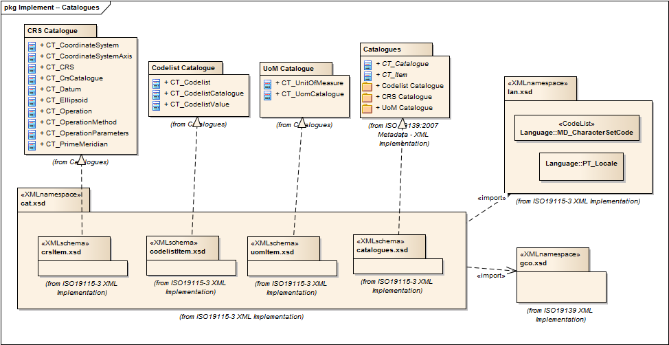
CATalogue |
1.2.0 |
Elements for codelist catalogues, and example catalogues. |
ISO 19115-1, Geographic Information - Metadata - Part 1: Fundamentals, 7.4.4 |
catalogue |
|
Catalog, Code List Item, uom Item, CRS Item |
lan.1.3, gco.1.2 |
|||||
2021 |
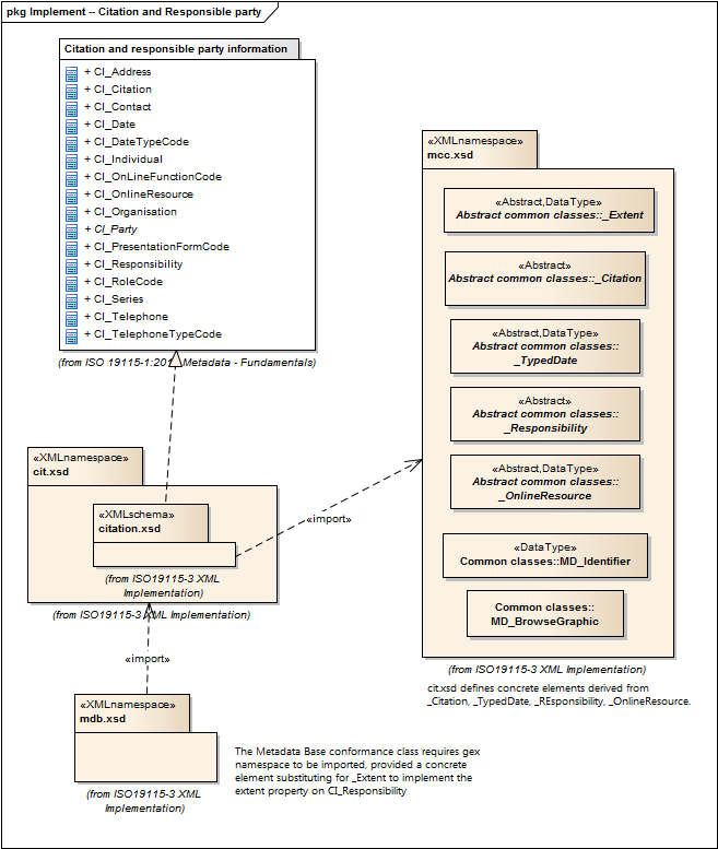
Citation and responsible party information |
1.3.0 |
Utility elements for citation, identification, and web linkage of resources. |
ISO 19115-1, Geographic Information - Metadata - Part 1: Fundamentals, 6.6.2 |
citation-metadata |
|
|
gco.1.2, mcc.1.3 |
||||
2021 |
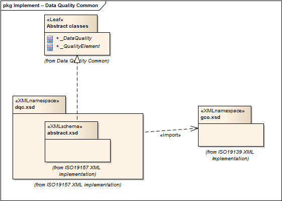
Data Quality Common Classes |
1.2.0 |
abstract classes shared by multiple namespaces and is required in order to enable modularization of the XML implementation. |
ISO 19157, Geographic Information - Data Quality, 6.4 |
data-quality-common |

|
Data Quality |
gco.1.2 |
||||
2021 |
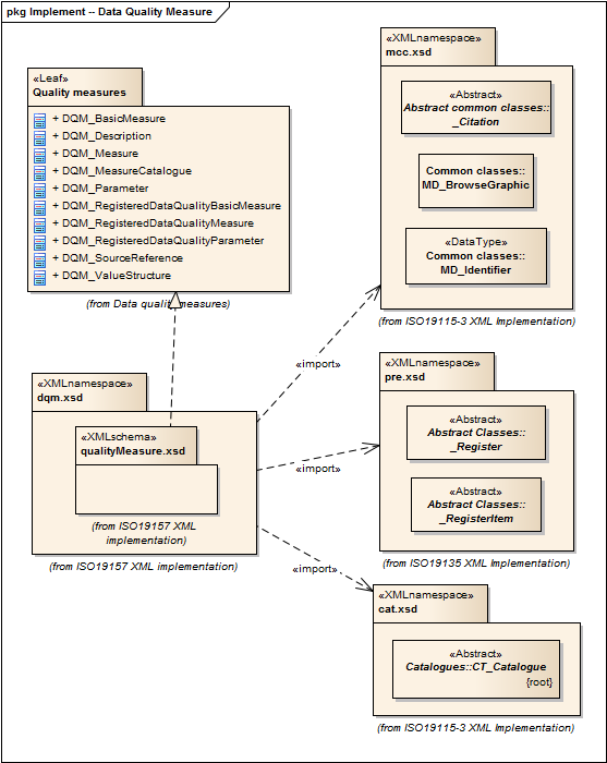
Data Quality Measures |
1.2.0 |
Elements for describing data quality measures. |
ISO 19157, Geographic Information - Data Quality, 6.5 |
quality-measures |
|
Data Quality |
cat.1.2, mcc.1.3, pre.1.1, gco.1.2 |
||||
2021 |
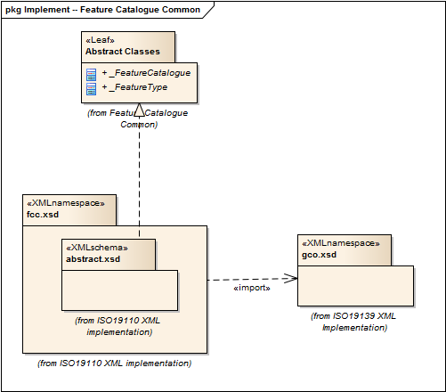
Feature Catalog Common |
2.2.0 |
abstract classes shared by multiple namespaces and is required in order to enable modularization of the XML implementation. |
ISO 19110, Geographic information — Methodology for feature cataloguing |
feature-catalog-common |
|
gco.1.2, cat.1.3 |
|||||
2021 |
Geographic COmmon |
1.2.0 |
Elements for describing basic types from ISO/TS 19103 and conceptual elements from ISO 19118 required in XML implementations of ISO metadata standards. |
ISO 19115-1, ISO/TS 19139 Geographic information - Metadata - XML schema implementation |
geographic-common |
No image available |
None |
xlink.1999 |
||||
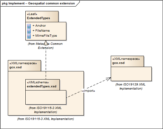
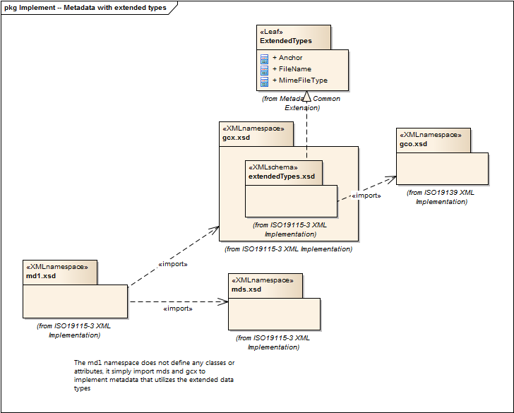
2021 |
Geospatial Common eXtension |
1.2.0 |
Elements for xml implementation, from ISO 19139 updated for compatibility with 19115-3. |
ISO 19115-1, Geographic Information - Metadata - Part 1: Fundamentals, 7.2 |
extended-types |

|
|
gco.1.2, xlink.1999, mcc.1.3 |
||||
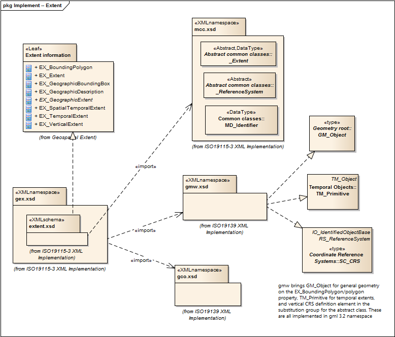
2021 |
Geospatial EXtent |
1.3.0 |
Elements for specifying geospatial properties of a resource, including extent and spatial reference systems. |
ISO 19115-1, Geographic Information - Metadata - Part 1: Fundamentals, 6.6.1 |
geospatial-extent |
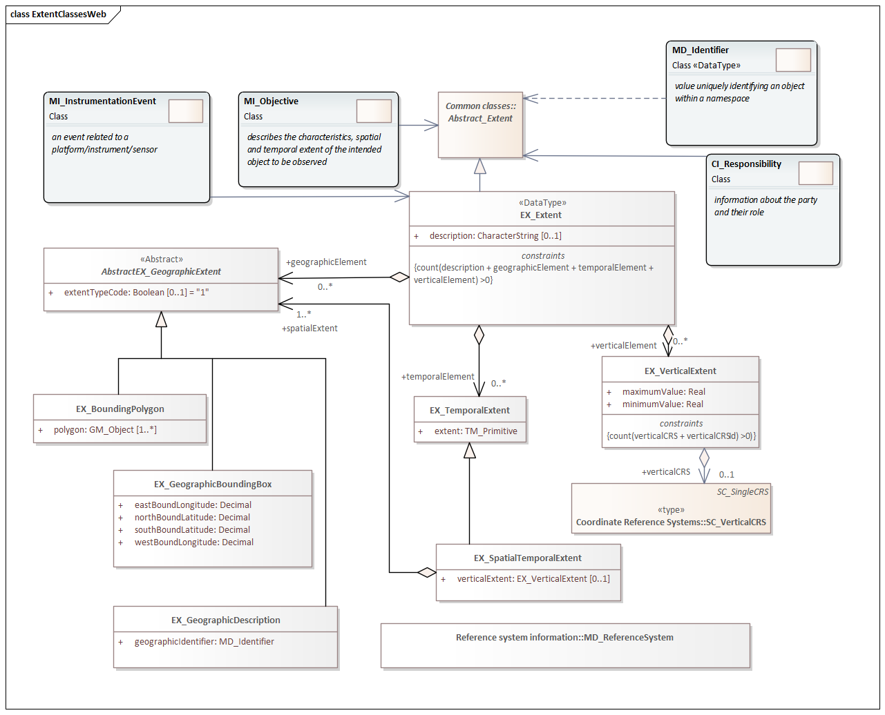
|
|
mcc.1.3, gco.1.2, gmw.1.2 |
||||
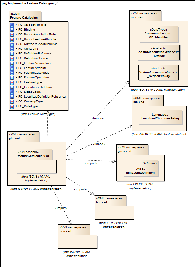
2021 |
General Feature Catalog |
2.2.0 |
ISO 19110:2005 defines the methodology for cataloguing feature types and specifies how the classification of feature types is organized into a feature catalogue and presented to the users of a set of geographic data. ISO 19110:2005 is applicable to creating catalogues of feature types in previously uncatalogued domains and to revising existing feature catalogues to comply with standard practice. ISO 19110:2005 applies to the cataloguing of feature types that are represented in digital form. Its principles can be extended to the cataloguing of other forms of geographic data. |
ISO 19110, Geographic information — Methodology for feature cataloguing |
feature-catalog |
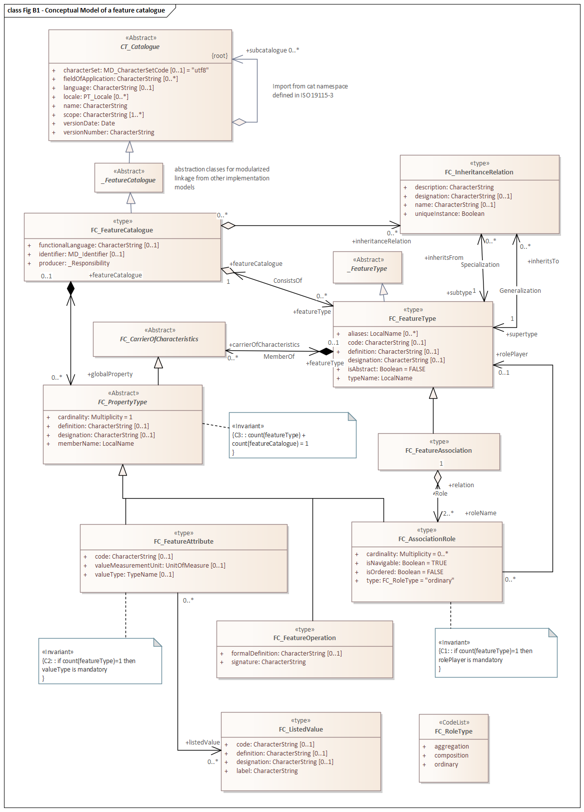
|
cit.1.3, fcc.2.2, lan.1.3, mcc.1.3, gco.1.2 |
|||||
2021 |
Geographic Markup Language for COVerages |
1.1.0 |
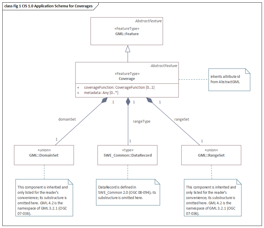
|
None |
gml, xlink.1999, gco.1.2 |
|||||||
2021 |
Geographic Markup Wrappers |
1.1.0 |
Wrappers for gml dependencies. |
ISO 19136-1 |
geographic-wrappers |
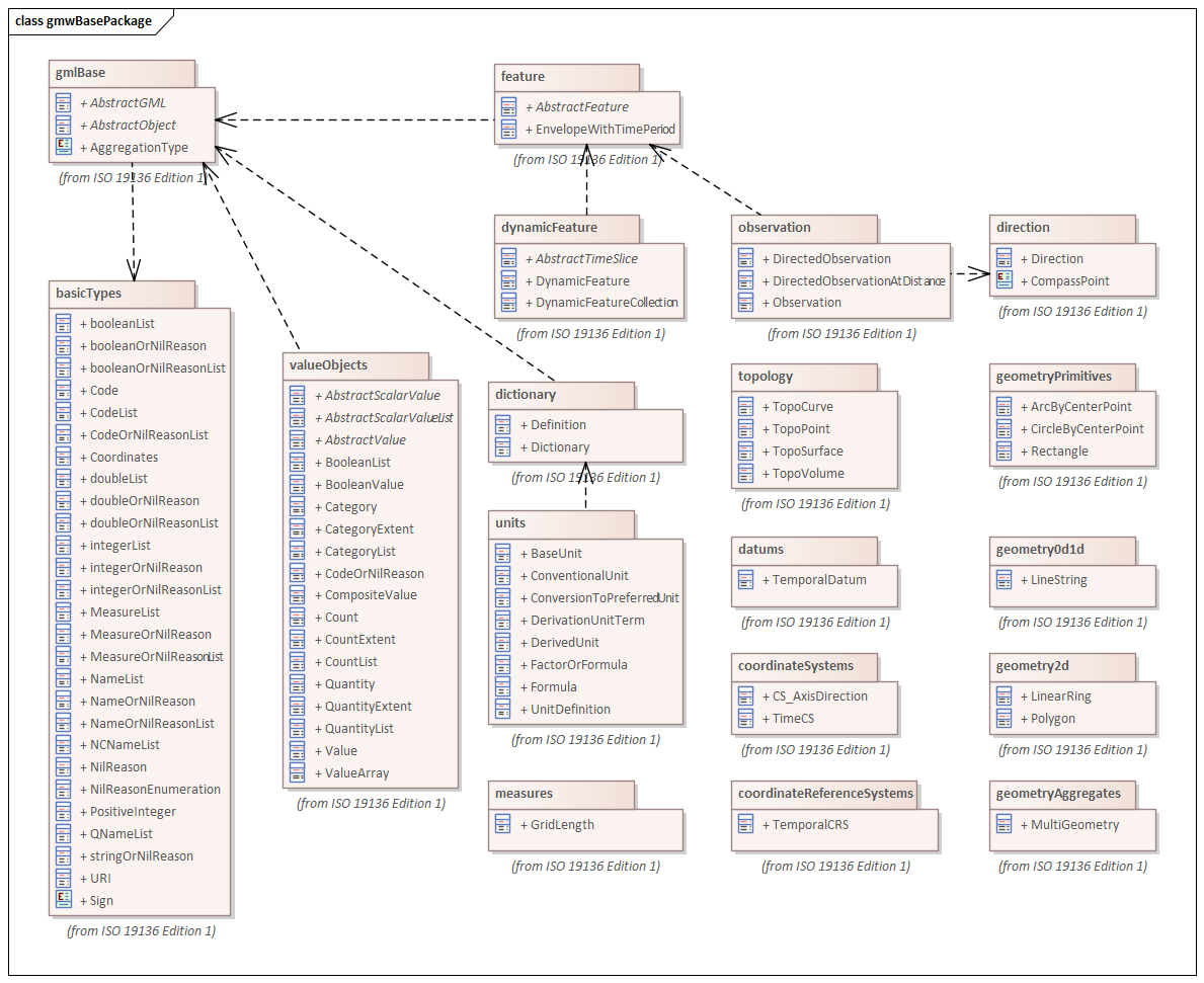
|
None |
gml, xlink.1999, baseTypes2014.1.0 |
||||
2021 |
Image and Gridded Data |
1.3.0 |
Elements for managing Image and Gridded Data. |
ISO 19163-1, Geographic Information - Content components and encoding rules for imagery and gridded data - Part 1: Content model |

|
|
gco/1.2; cit/1.3; gex/1.3; mri/1.3 msr/1.3; mrc/1.3; mac/2.2; gml/3.2; gmw/1.1; gmlcov0/1.0 |
|||||
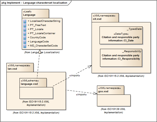
2021 |
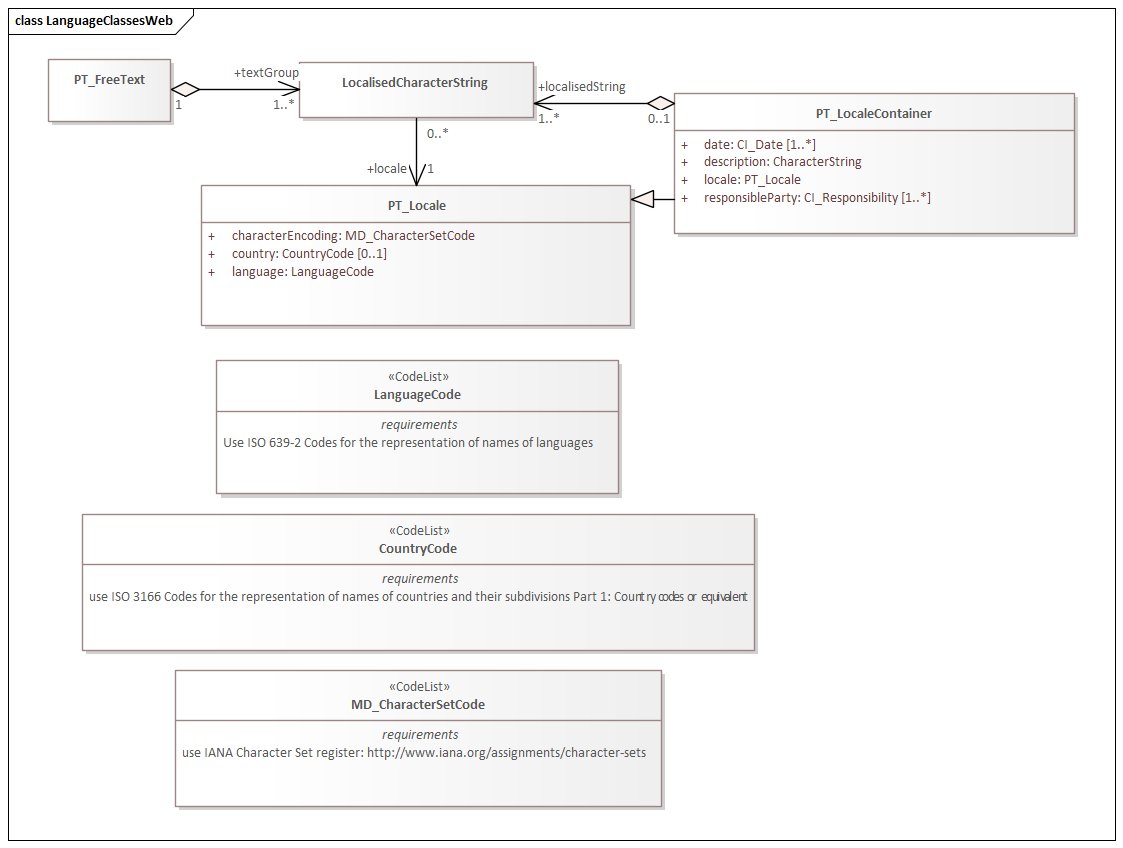
Language localization |
1.3.0 |
Elements for cultural and linguistic adapatiblity. |
ISO 19115-1, Geographic Information - Metadata - Part 1: Fundamentals, 7.3 |
language-localization |
|
|
gco.1.1, cit.1.3 |
||||
2021 |
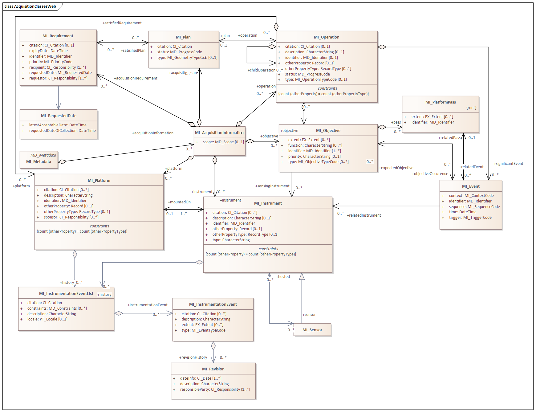
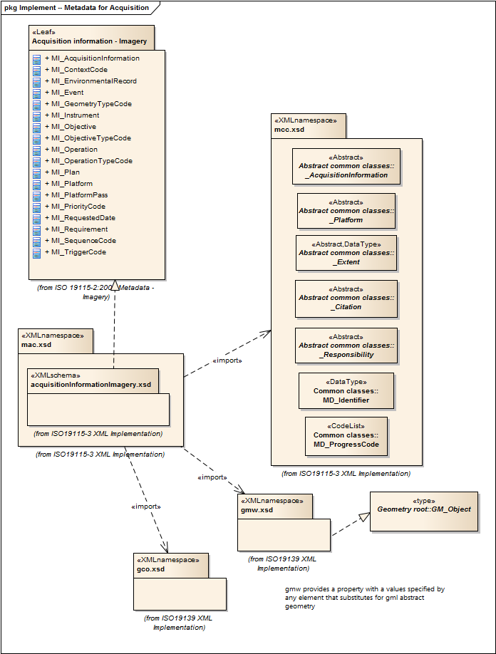
Metadata for Acquisition |
2.2.0 |
Information related to acquisition platforms, instruments, operations and other details. |
ISO 19115-2, Geographic Information - Metadata - Part 2: Extensions for acquisition and processing, 6.3.2 |
|
Acquisition Details |
gco.1.2, gmw.1.2, mcc.1.3, lan.1.3 |
|||||
2021 |
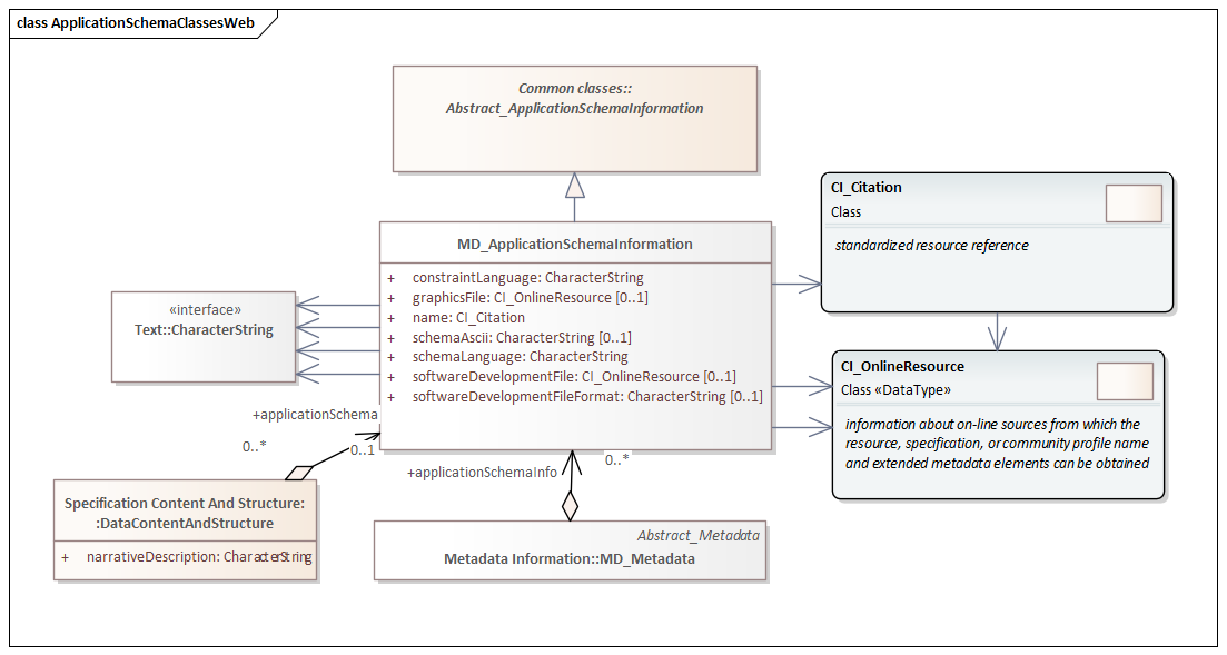
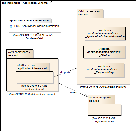
Metadata for Application Schema |
1.3.0 |
Elements for referencing Application Schema. |
ISO 19115-1, Geographic Information - Metadata - Part 1: Fundamentals, 6.5.13 |
application-schema |
|
|
gco.1.2, mcc.1.3, cit.1.30 |
||||
2021 |
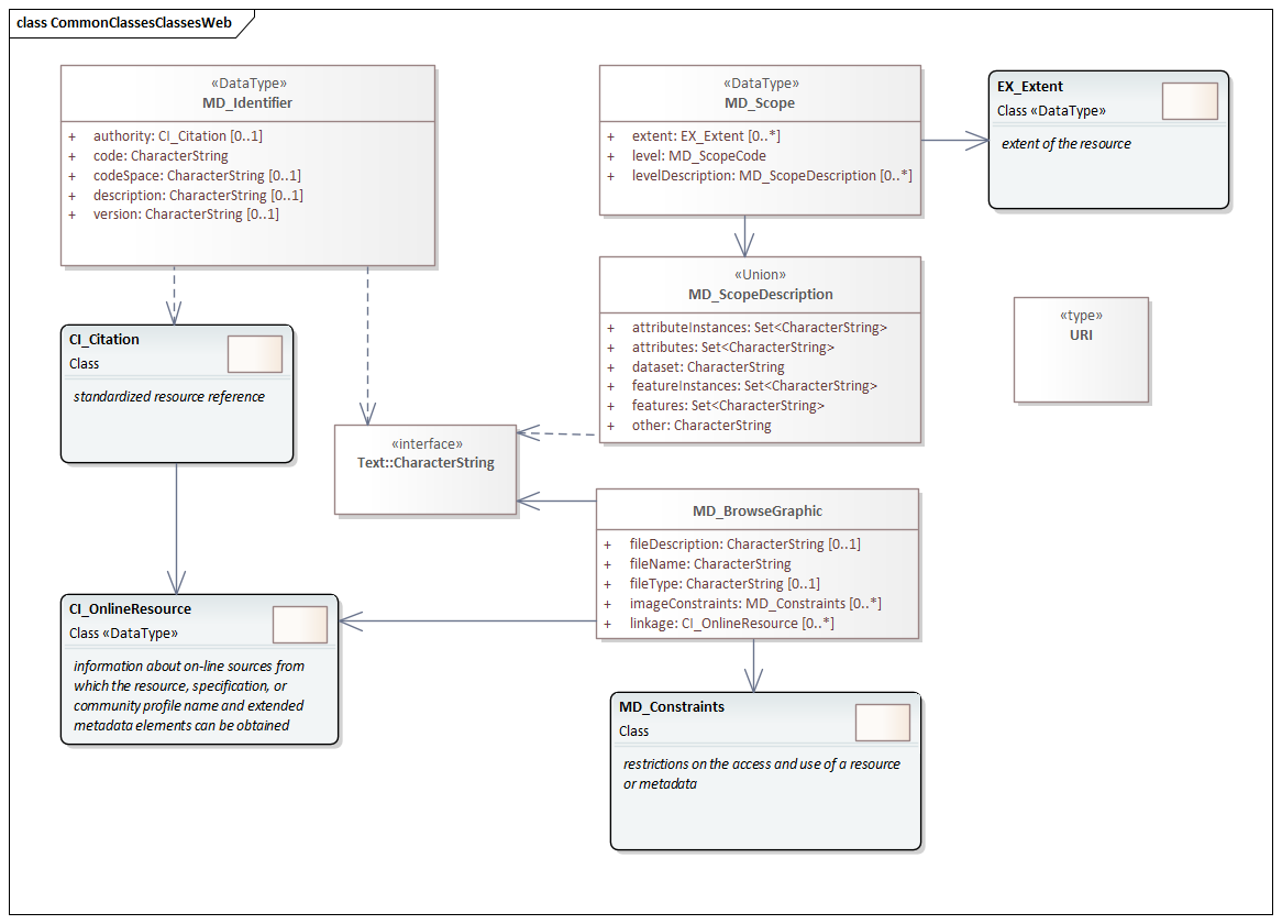
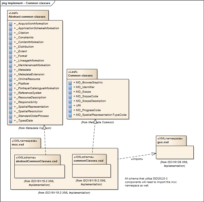
Metadata Common Classes |
1.3.0 |
abstract classes shared by multiple namespaces and is required in order to enable modularization of the XML implementation. |
ISO 19115-1, Geographic Information - Metadata - Part 1: Fundamentals, 6.6.4 |
common-classes |
|
gco.1.2 |
|||||
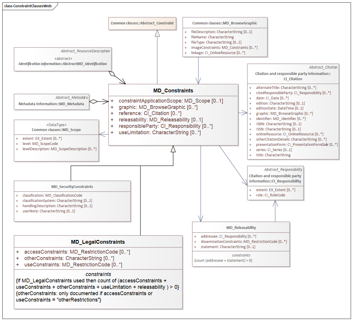
2021 |
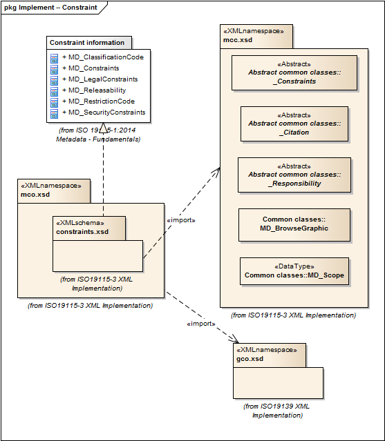
Metadata for Constraints |
1.3.0 |
Elements for describing resource and metadata constraints. |
ISO 19115-1, Geographic Information - Metadata - Part 1: Fundamentals, 6.5.4 and ISO 19115-2, Geographic Information - Metadata - Part 2: Extensions for acquisition |
constraints |
|
|
gco.1.2, mcc.1.3 |
||||
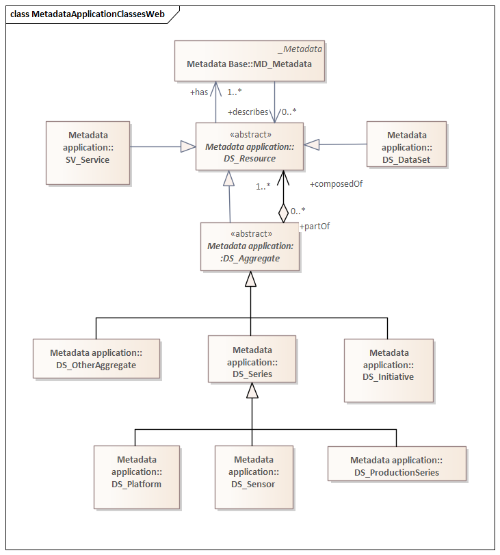
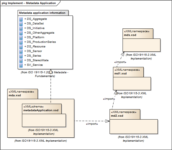
2021 |
MetaData Application |
1.3.0 |
Elements to represent resources that may be aggregated and described by metadata records (DS_*) |
ISO 19115-1, Geographic Information - Metadata - Part 1: Fundamentals, 6.2 |
metadata-application |
|
|
gco.1.2, mdb.1.3 |
||||
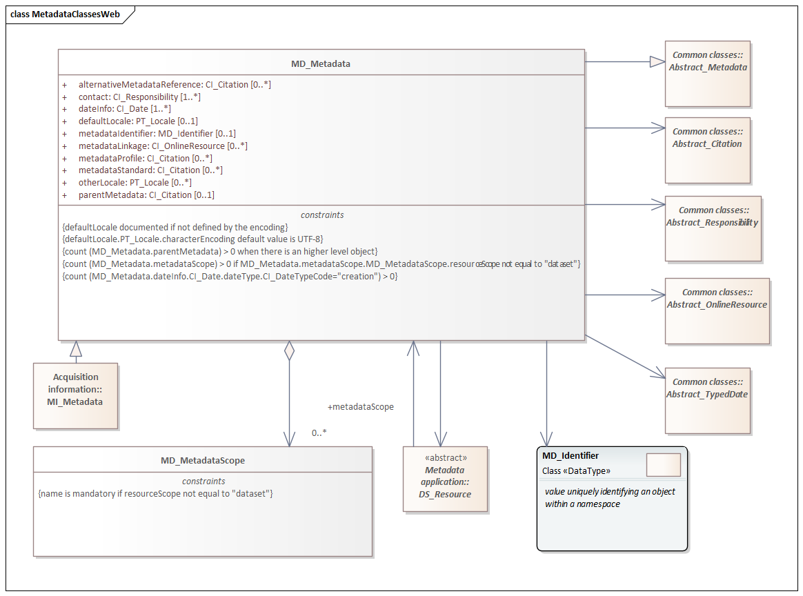
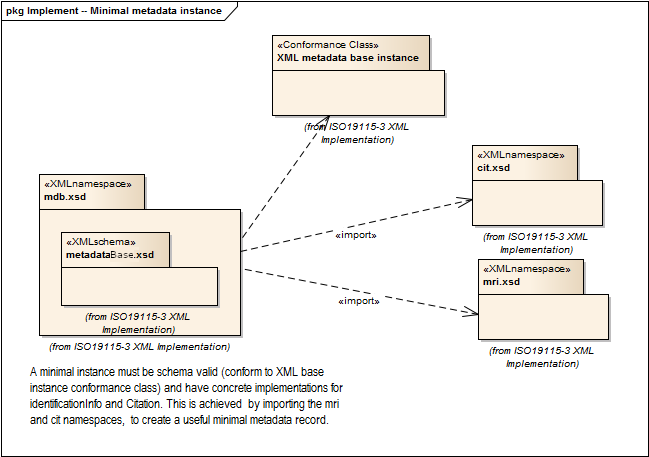
2021 |
Metadata Base |
1.3.0 |
Mandatory elements for describing resources that are not services. This namespace is used for metadata records that include only mandatory elements. |
ISO 19115-1, Geographic Information - Metadata - Part 1: Fundamentals, 6.5.2 |
metadata-base |
|
cit.1.3, dqc.1.1, lan.1.3, mcc.1.3, mri.1.3, gex.1.2, gco.1.2 |
|||||
2021 |
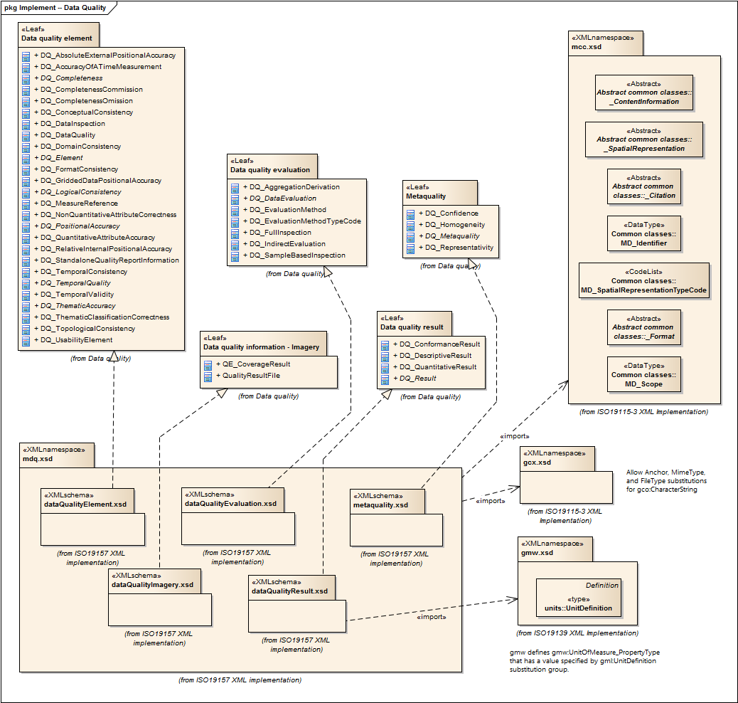
Metadata for Data Quality |
1.21.0 |
Elements for describing the quality of resources. |
ISO 19157, Geographic Information - Data Quality, 6.4 |
data-quality |
|
Data Quality |
dqc.1.1, gcx.1.2, mcc.1.3, gco.1.2, gmw.1.2, mrd.1.3 |
||||
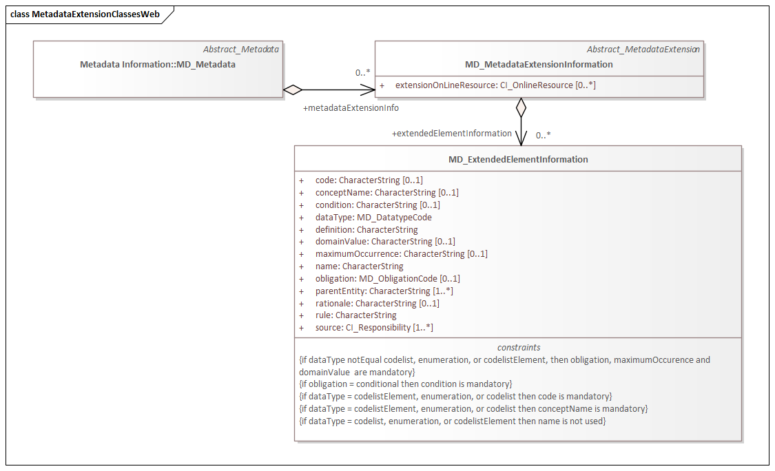
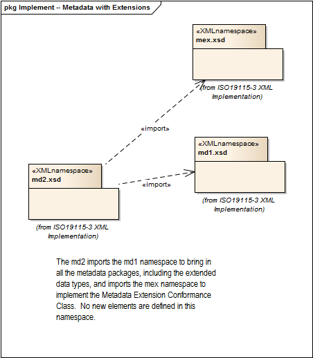
2021 |
Metadata with Schema Extensions |
1.3.0 |
Elements describing extensions to metadata standards. |
ISO 19115-1, Geographic Information - Metadata - Part 1: Fundamentals, 6.5.12 |
metadata-extension |
|
|
mcc.1.3, gco.1.2 |
||||
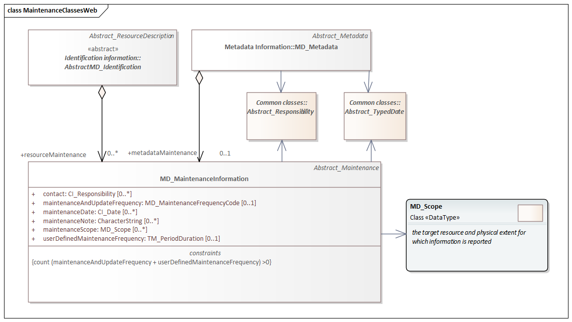
2021 |
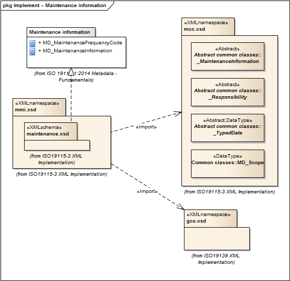
Metadata for Maintenance Information |
1.3.0 |
Elements describing resource and metadata maintenance. |
ISO 19115-1, Geographic Information - Metadata - Part 1: Fundamentals, 6.5.6 |
maintenance-information |
|
|
mcc.1.3, gco.1.2 |
||||
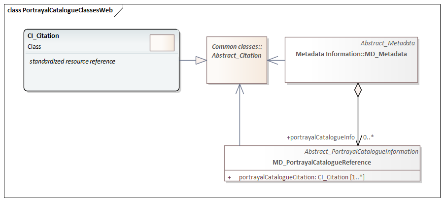
2021 |
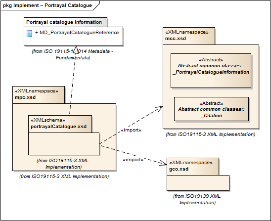
Metadata for Portrayal Catalog |
1.3.0 |
Elements for referencing portrayal catalogs. |
ISO 19115-1, Geographic Information - Metadata - Part 1: Fundamentals, 6.5.10 |
portrayal-catalog |
|
|
gco.1.2, mcc.1.3 |
||||
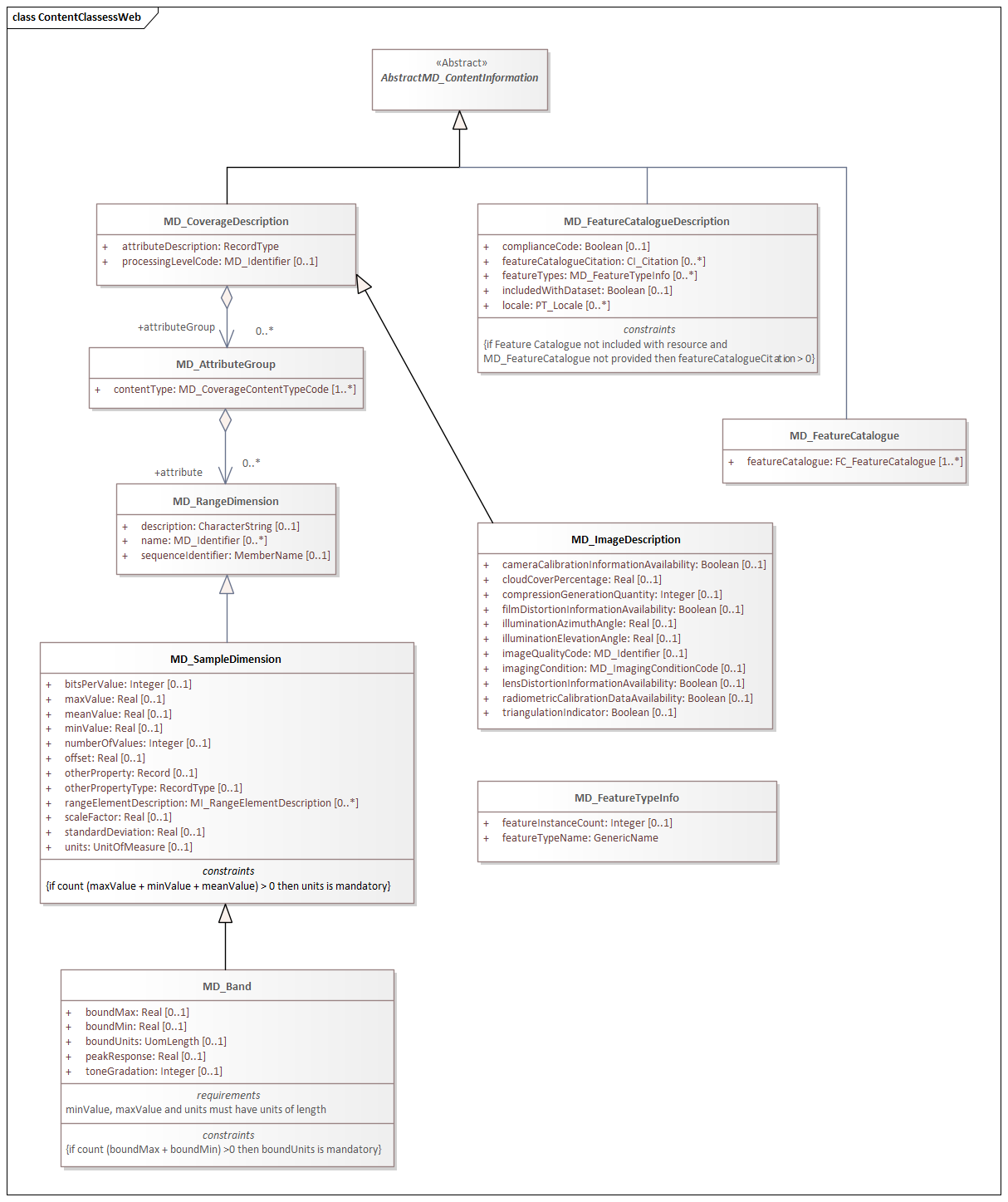
2021 |
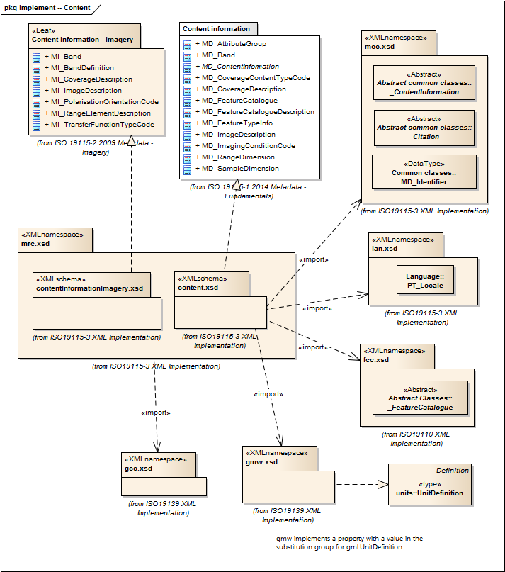
Metadata for Resource Content |
1.3.0 |
Elements for describing resource structure and content. |
ISO 19115-1, Geographic Information - Metadata - Part 1: Fundamentals, 6.5.9 and ISO 19115-2, Geographic Information - Metadata - Part 2: Extensions for acquisition |
resource-content |
|
|
gco.1.2, fcc.2.2, lan.1.3, mcc.1.3, gmw.1.2 |
||||
2021 |
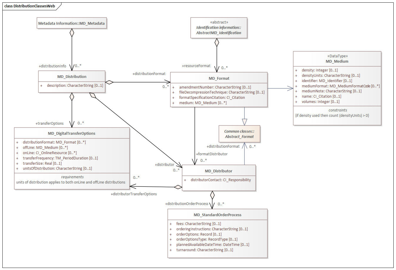
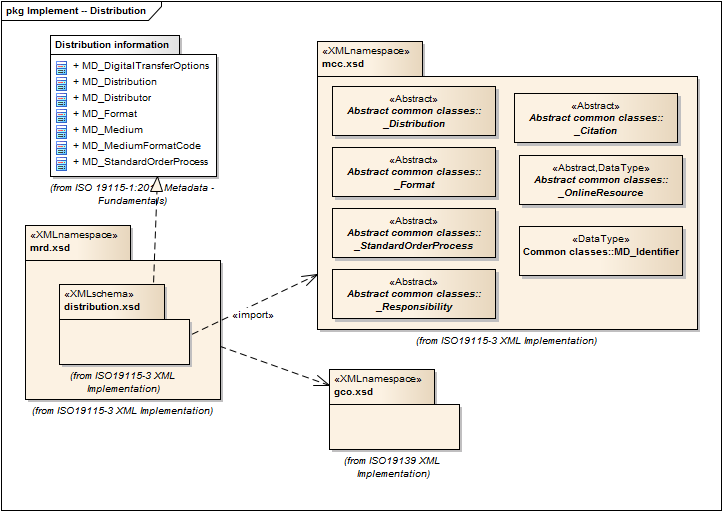
Metadata for Resource Distribution |
1.3.0 |
Elements specifying how a resource is accessed. |
ISO 19115-1, Geographic Information - Metadata - Part 1: Fundamentals, 6.5.11 |
resource-distribution |
|
|
gco.1.2, mcc.1.3 |
||||
2021 |
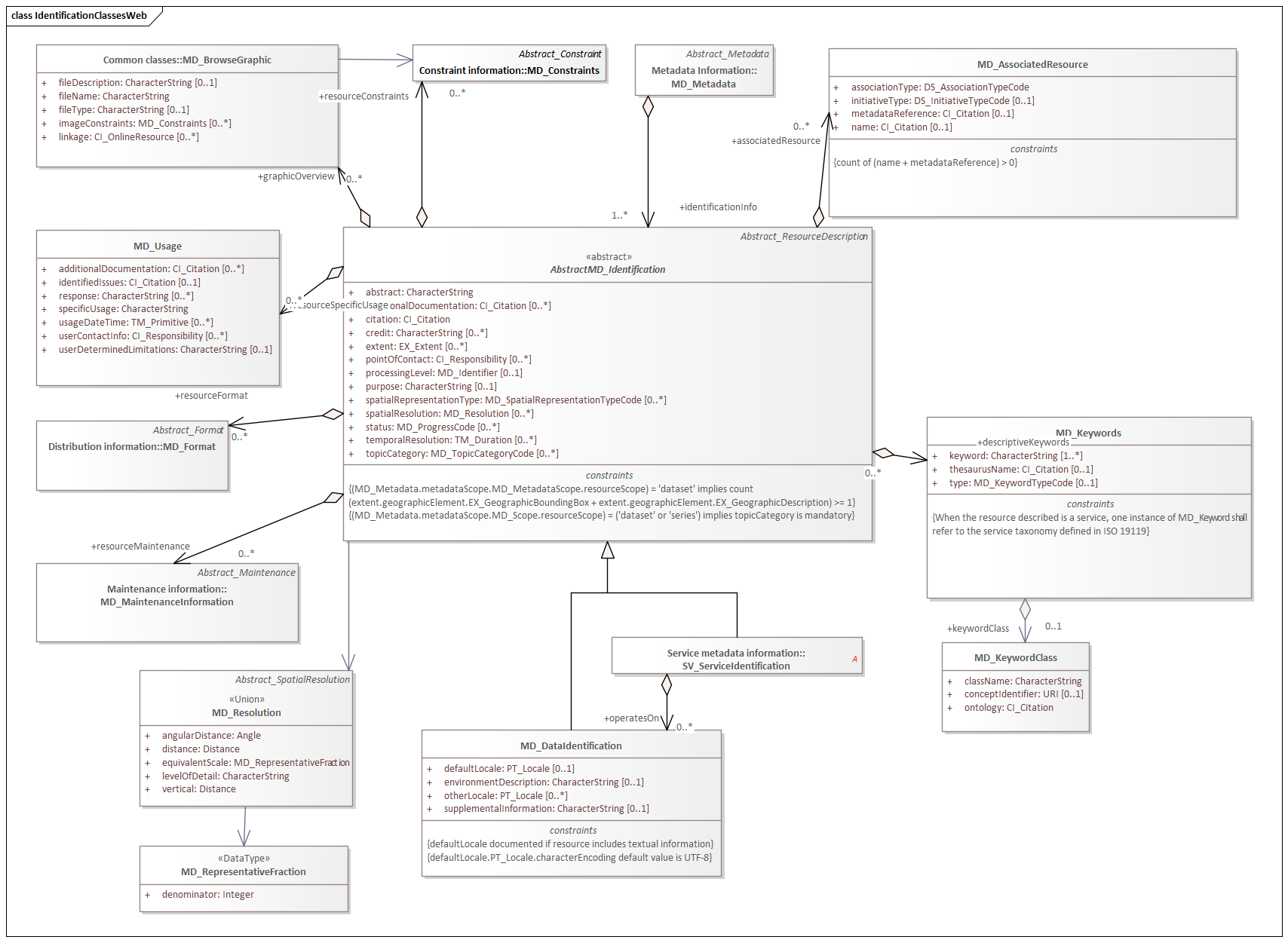
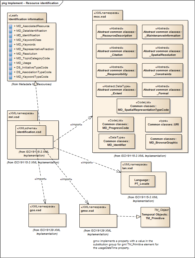
Metadata for Resource Identification |
1.3.0 |
Elements for identifying resources. |
ISO 19115-1, Geographic Information - Metadata - Part 1: Fundamentals, 6.5.3 |
resource-identification |
|
|
lan.1.3, mcc.1.3, gco.1.2, gmw.1.2 |
||||
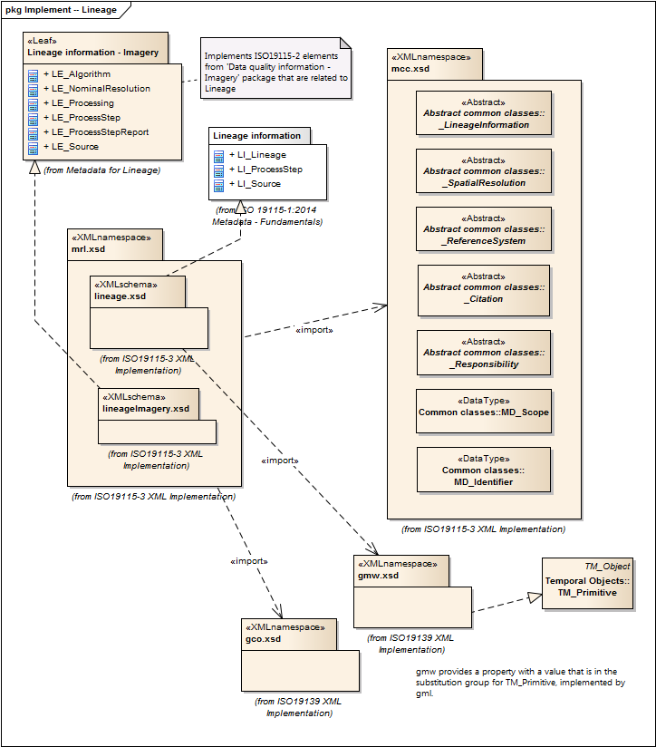
2021 |
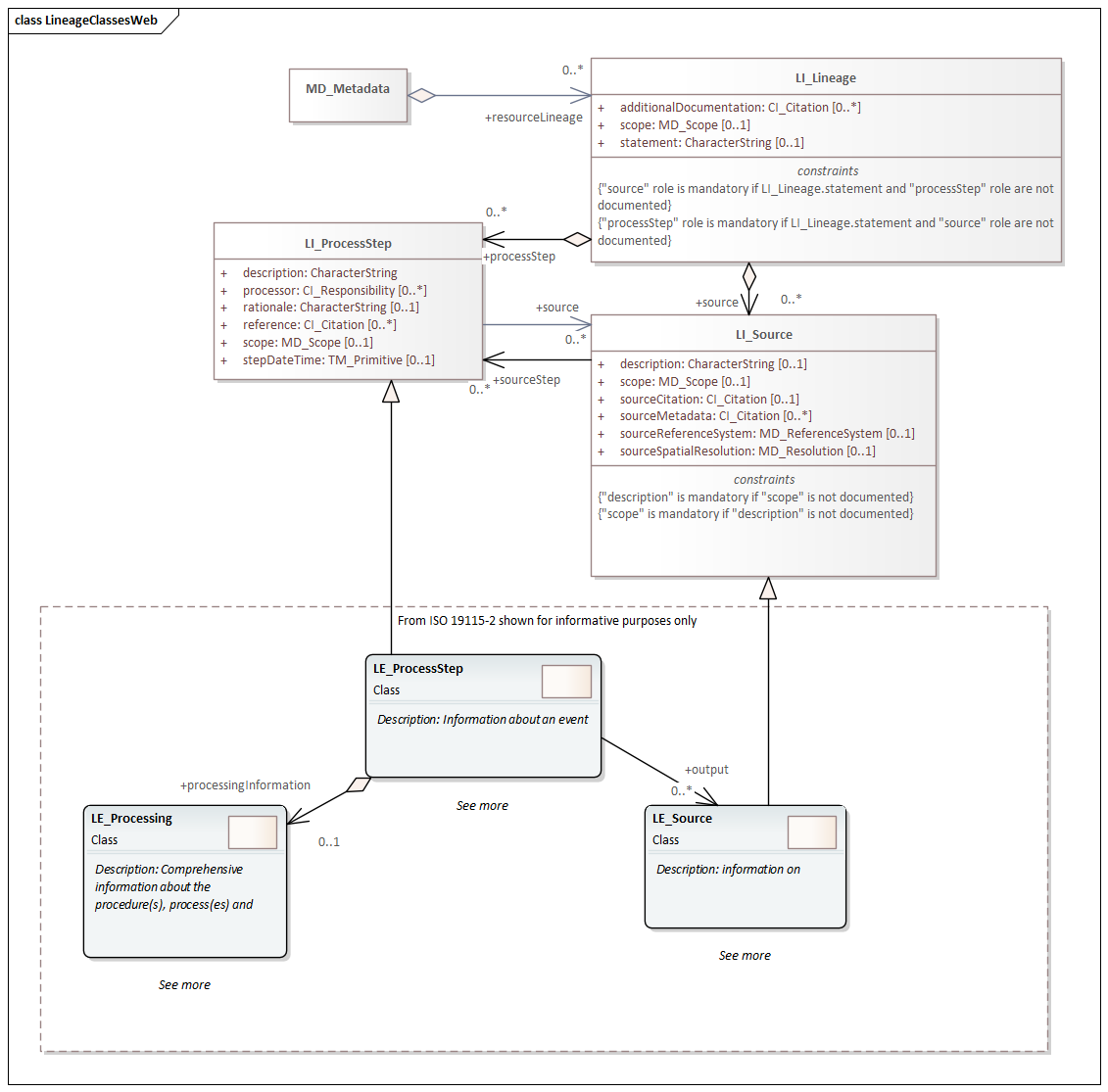
Metadata for Resource Lineage |
1.3.0 |
Elements for describing resource lineage. |
ISO 19115-1, Geographic Information - Metadata - Part 1: Fundamentals and ISO 19115-2, Geographic Information - Metadata - Part 2: Extensions for acquisition, 6.3.3 |
lineage |
|
gco.1.2, mcc.1.3, srv.1.3, gmw.1.2 |
|||||
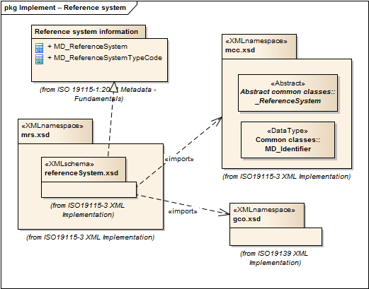
2021 |
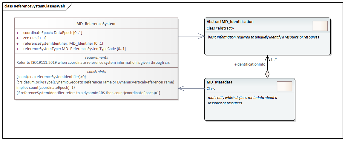
Metadata for Reference System |
1.3.0 |
Elements for describing Reference Systems. |
ISO 19115-1, Geographic Information - Metadata - Part 1: Fundamentals, 6.5.8 |
reference-system |
|
|
gco.1.2, mcc.1.3 |
||||
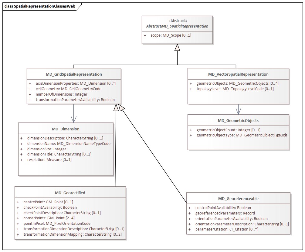
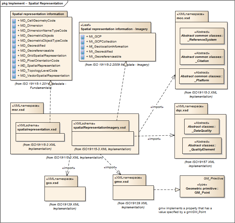
2021 |
Metadata for Spatial Representation |
2.0 |
Elements for describing spatial representations of resources. |
ISO 19115-1, Geographic Information - Metadata - Part 1: Fundamentals AMENDMENT 1, 6.5.7 and ISO 19115-2, Geographic Information - Metadata - Part 2: Extensions for acquisition |
spatial-representation |
|
|
gco.1.2, gmw.1.2, mcc.1.2, dqc.1.1 |
||||
2021 |
Referencing By Coordinates |
3.1.0 |
This part of ISO 19135 specifies procedures for the registration of items of geographic information. ISO/IEC JTC 1 defines registration as the assignment of an unambiguous name to an object in a way that makes the assignment available to interested parties. |
ISO 19135, Geographic information - Procedures for item registration - Part 1: Fundamentals |
Procedures for Item Registration |
|
gco.1.2, cit.1.3 |
|||||
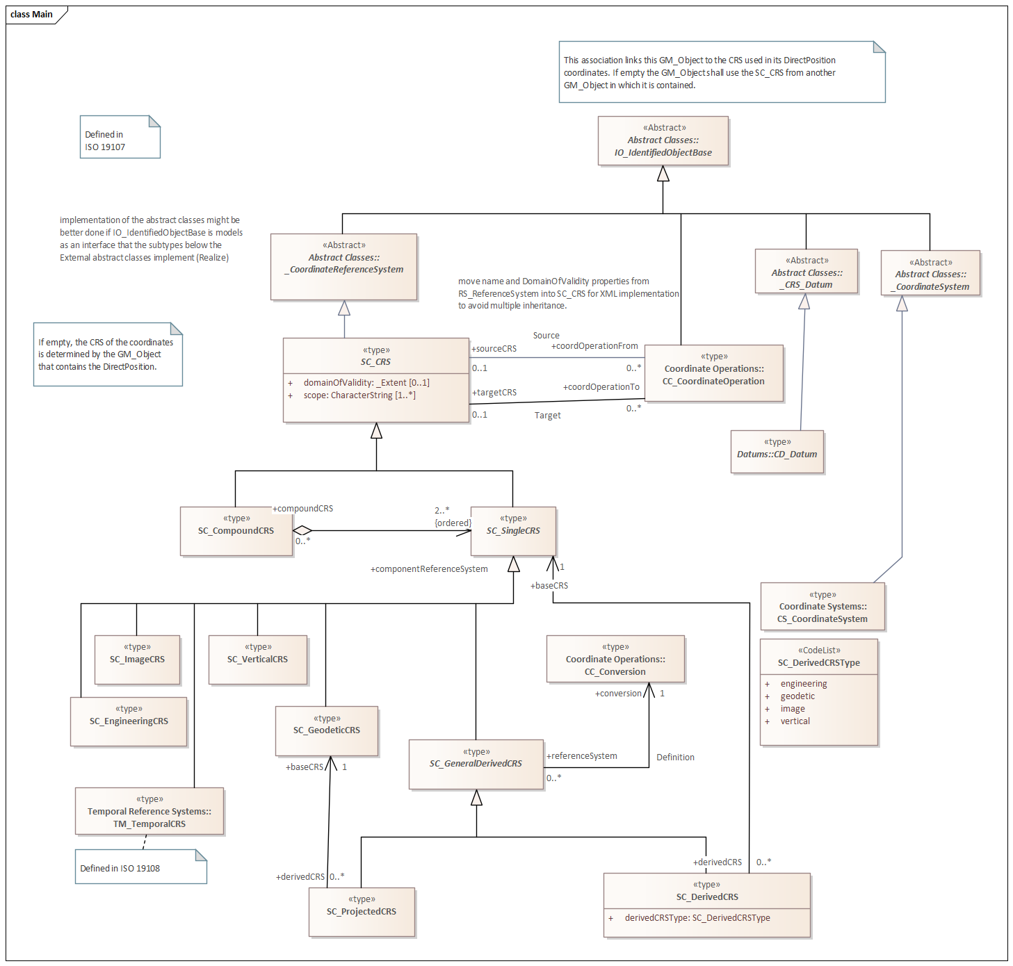
2021 |
Referencing By Coordinates |
3.1.0 |
ISO 19111:2019 defines the conceptual schema for the description of spatial referencing by coordinates, optionally extended to spatio-temporal referencing. It describes the minimum data required to define one-, two- and three-dimensional spatial coordinate reference systems with an extension to merged spatial-temporal reference systems. It allows additional descriptive information to be provided. It also describes the information required to change coordinates from one coordinate reference system to another. |
ISO 19111, Geographic information — Spatial referencing by coordinates |
Reference by Coordinate |
|
gco.1.2, mcc.1.3 |
|||||
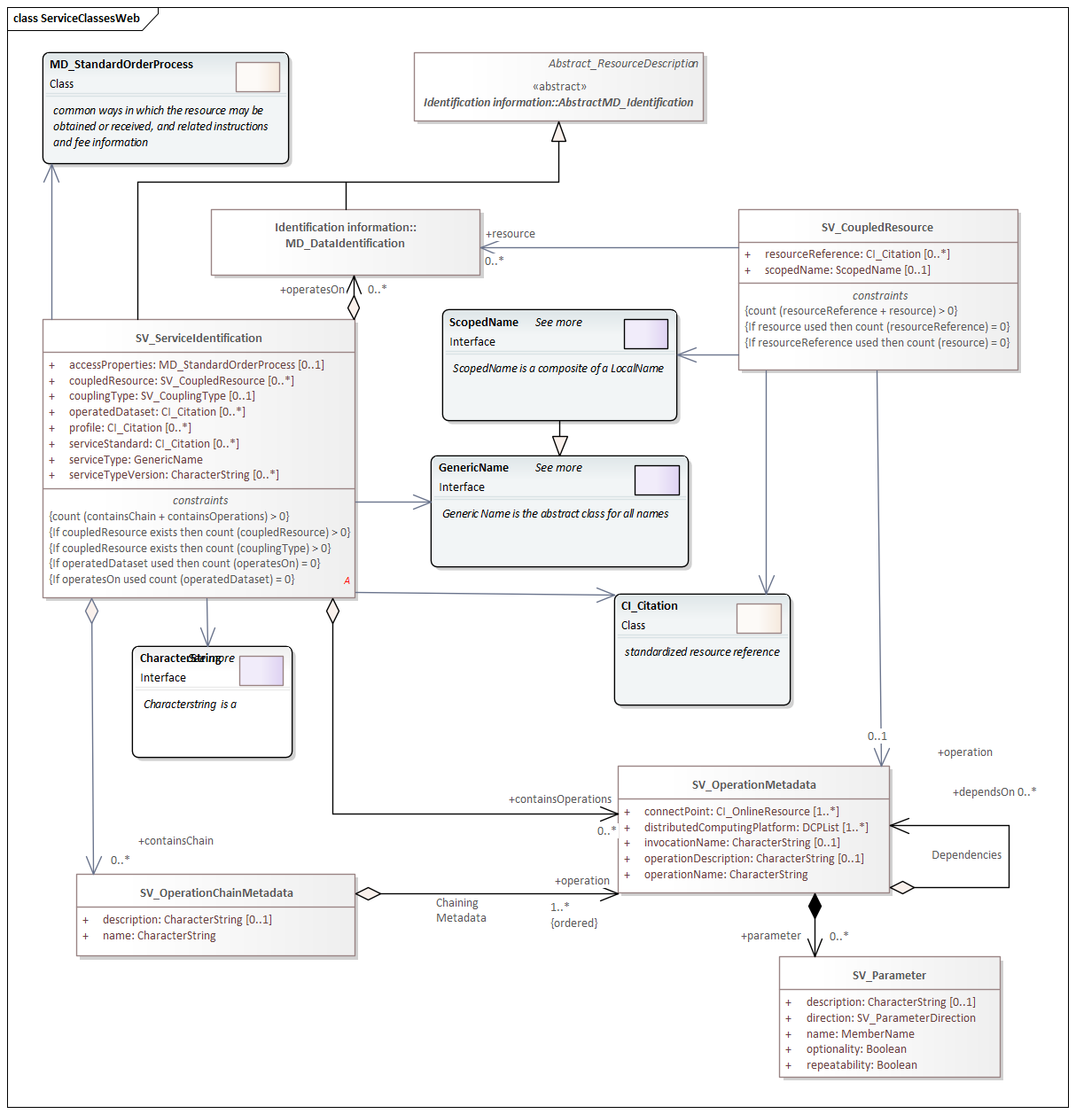
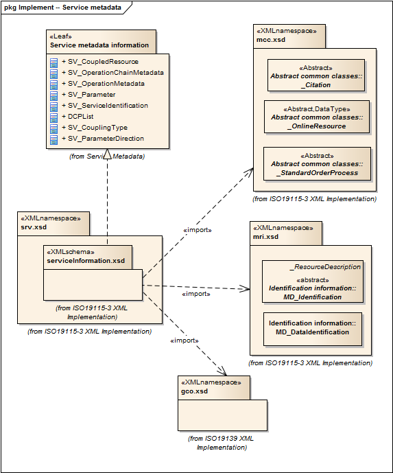
2021 |
metadata for SeRVices |
1.3.0 |
Elements for describing services. |
ISO 19115-1, Geographic Information - Metadata - Part 1: Fundamentals, 6.5.14 |
services |
|
|
gco.1.2, mcc.1.3, mri.1.3 |
Previous sets of namespaces (pre-2020)
| Year | Standard Prefix | Title | Version | Scope | Standard, Paragraph | Requirements Name | Namespace URI | Thumbnail | UML Package | XML Schema | XML Schema Included | Imported Namespaces |
|---|---|---|---|---|---|---|---|---|---|---|---|---|
2019 |
CATalogue |
1.0 |
Elements for codelist catalogues, and example catalogues. |
ISO 19115-1, Geographic Information - Metadata - Part 1: Fundamentals, 7.4.4 |
catalogue |

|
Catalog, Code List Item, uom Item, CRS Item |
lan.1.0, gco.1.0 |
||||
2019 |
Citation and responsible party information |
2.0 |
Utility elements for citation, identification, and web linkage of resources. |
ISO 19115-1, Geographic Information - Metadata - Part 1: Fundamentals AMENDMENT 1, 6.6.2 |
citation-metadata |
|
|
gco.1.0, mcc.1.0 |
||||
2019 |
Data Quality Common Classes |
1.0 |
abstract classes shared by multiple namespaces and is required in order to enable modularization of the XML implementation. |
ISO 19157, Geographic Information - Data Quality, 6.4 |
data-quality-common |
|
Data Quality |
gco.1.0 |
||||
2019 |
Data Quality Measures |
1.0 |
Elements for describing data quality measures. |
ISO 19157, Geographic Information - Data Quality, 6.5 |
quality-measures |
|
Data Quality |
cat.1.0, mcc.1.0, pre.1.0, gco.1.0 |
||||
2019 |
Feature Catalog Common |
1.0 |
abstract classes shared by multiple namespaces and is required in order to enable modularization of the XML implementation. |
ISO 19110, Geographic information — Methodology for feature cataloguing |
feature-catalog-common |
|
gco.1.0, cat.1.0 |
|||||
2019 |
Geographic COmmon |
1.0 |
Elements for describing basic types from ISO/TS 19103 and conceptual elements from ISO 19118 required in XML implementations of ISO metadata standards. |
ISO 19115-1, ISO/TS 19139 Geographic information - Metadata - XML schema implementation |
geographic-common |
No image available |
None |
xlink.1999 |
||||
2019 |
Geospatial Common eXtension |
1.0 |
Elements for xml implementation, from ISO 19139 updated for compatibility with 19115-3. |
ISO 19115-1, Geographic Information - Metadata - Part 1: Fundamentals, 7.2 |
extended-types |
|
|
gco.1.0, xlink.1999, mcc.1.0 |
||||
2019 |
Geospatial EXtent |
1.0 |
Elements for specifying geospatial properties of a resource, including extent and spatial reference systems. |
ISO 19115-1, Geographic Information - Metadata - Part 1: Fundamentals, 6.6.1 |
geospatial-extent |
|
|
mcc.1.0, gco.1.0, gmw.1.0 |
||||
2019 |
General Feature Catalog |
1.1 |
ISO 19110:2005 defines the methodology for cataloguing feature types and specifies how the classification of feature types is organized into a feature catalogue and presented to the users of a set of geographic data. ISO 19110:2005 is applicable to creating catalogues of feature types in previously uncatalogued domains and to revising existing feature catalogues to comply with standard practice. ISO 19110:2005 applies to the cataloguing of feature types that are represented in digital form. Its principles can be extended to the cataloguing of other forms of geographic data. |
ISO 19110, Geographic information — Methodology for feature cataloguing |
feature-catalog |
|
cit.1.0, fcc.1.0, lan.1.0, mcc.1.0, gco.1.0 |
|||||
2019 |
Geographic Markup Wrappers |
1.0 |
Wrappers for gml dependencies. |
ISO 19115-1, Geographic Information - Metadata - Part 1: Fundamentals |
geographic-wrappers |
No image available |
None |
gml, xlink.1999, baseTypes2014.1.0 |
||||
2019 |
Language localization |
1.0 |
Elements for cultural and linguistic adapatiblity. |
ISO 19115-1, Geographic Information - Metadata - Part 1: Fundamentals, 7.3 |
language-localization |
|
|
gco.1.0, cit.1.0 |
||||
2019 |
Metadata for Acquisition |
1.0 |
Information related to acquisition platforms, instruments, operations and other details. |
ISO 19115-2, Geographic Information - Metadata - Part 2: Extensions for imagery and gridded data, A.2.5 |

|
Acquisition Details |
gco.1.0, gmw.1.0, mcc.1.0 |
|||||
2019 |
Metadata for Acquisition |
2.0 |
Information related to acquisition platforms, instruments, operations and other details. |
ISO 19115-2, Geographic Information - Metadata - Part 2: Extensions for acquisition and processing, 6.3.2 |
|
Acquisition Details |
gco.1.0, gmw.1.0, mcc.1.0, lan.1.0 |
|||||
2019 |
Metadata for Application Schema |
1.0 |
Elements for referencing Application Schema. |
ISO 19115-1, Geographic Information - Metadata - Part 1: Fundamentals, 6.5.13 |
application-schema |
|
|
gco.1.0, mcc.1.0, cit.1.0 |
||||
2019 |
Metadata Common Classes |
1.0 |
abstract classes shared by multiple namespaces and is required in order to enable modularization of the XML implementation. |
ISO 19115-1, Geographic Information - Metadata - Part 1: Fundamentals, 6.6.4 |
common-classes |
|
gco.1.0 |
|||||
2019 |
Metadata for Constraints |
1.0 |
Elements for describing resource and metadata constraints. |
ISO 19115-1, Geographic Information - Metadata - Part 1: Fundamentals, 6.5.4 |
constraints |
|
|
gco.1.0, mcc.1.0 |
||||
2019 |
Metadata for Data and Services with Geospatial Common Extensions |
1.0 |
This namespace contains all classes needed for a complete metadata record for any resource and enables the use of FileName, MimeType, and Anchor elements (gex). |
ISO 19115-1, Geographic Information - Metadata - Part 1: Fundamentals, A.2.3.4 |
metadata-extended-types-instance |
|
Implementation Model Only |
gcx.1.0, mds.1.0 |
||||
2019 |
Metadata for Data and Services with Geospatial Common Extensions |
2.0 |
This namespace contains all classes needed for a complete metadata record for any resource and enables the use of FileName, MimeType, and Anchor elements (gex). |
ISO 19115-1, Geographic Information - Metadata - Part 1: Fundamentals, A.2.3.4 |
metadata-extended-types-instance |

|
Implementation Model Only |
gcx.1.0, mds.2.0 |
||||
2019 |
Metadata with Extended Schema |
1.0 |
This namespace contains all classes needed for a complete metadata record for any resource and enables the description of schema extensions (MD_MetadataExtensionInformation) elements (mex). |
ISO 19115-1, Geographic Information - Metadata - Part 1: Fundamentals, A.2.3.5 |
extended-metadata-instance |

|
Implementation Model Only |
cit.1.0, gcx.1.0, lan.1.0, mcc.1.0, md1.1.0, mex.1.0, mpc.1.0, mri.1.0 |
||||
2019 |
Metadata with Extended Schema |
2.0 |
This namespace contains all classes needed for a complete metadata record for any resource and enables the description of schema extensions (MD_MetadataExtensionInformation) elements (mex). |
ISO 19115-1, Geographic Information - Metadata - Part 1: Fundamentals, A.2.3.5 |
extended-metadata-instance |
|
Implementation Model Only |
cit.2.0, gcx.1.0, lan.1.0, mcc.1.0, md1.2.0, mex.1.0, mpc.1.0, mri.1.0 |
||||
2019 |
MetaData Application |
1.0 |
Elements to represent resources that may be aggregated and described by metadata records (DS_*) |
ISO 19115-1, Geographic Information - Metadata - Part 1: Fundamentals, 6.2 |
metadata-application |
|
|
md2.1.0, gco.1.0, mdb.1.0 |
||||
2019 |
MetaData Application |
2.0 |
Elements to represent resources that may be aggregated and described by metadata records (DS_*) |
ISO 19115-1, Geographic Information - Metadata - Part 1: Fundamentals, 6.2 |
metadata-application |

|
|
md2.2.0, gco.1.0, mdb.2.0 |
||||
2019 |
Metadata Base |
1.0 |
Mandatory elements for describing resources that are not services. This namespace is used for metadata records that include only mandatory elements. |
ISO 19115-1, Geographic Information - Metadata - Part 1: Fundamentals, 6.5.2 |
metadata-base |

|
cit.1.0, dqc.1.0, lan.1.0, mcc.1.0, mri.1.0, gex.1.0, gco.1.0 |
|||||
2019 |
Metadata Base |
2.0 |
Mandatory elements for describing resources that are not services. This namespace is used for metadata records that include only mandatory elements. |
ISO 19115-1, Geographic Information - Metadata - Part 1: Fundamentals, 6.5.2 |
metadata-base |
|
cit.2.0, dqc.1.0, lan.1.0, mcc.1.0, mri.1.0, gex.1.0, gco.1.0 |
|||||
2019 |
Metadata for Data Quality |
1.0 |
Elements for describing the quality of resources. |
ISO 19157, Geographic Information - Data Quality, 6.4 |
data-quality |
|
Data Quality |
dqc.1.0, gcx.1.0, mcc.1.0, gco.1.0, gmw.1.0, mrd.1.0 |
||||
2019 |
Metadata for Data and Services |
1.0 |
This namespace contains all classes needed for a complete metadata record for any resource. It is used for metadata records that do not include geospatial common extensions (gex), extenbsions to the schema (mex), data series (DS_*) elements (mda) or metadata for data transfer (mdt). |
ISO 19115-1, Geographic Information - Metadata - Part 1: Fundamentals, 6.5.2 |
metadata-data-or-services |
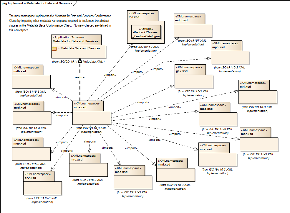
|
fcc.1.0, gex.1.0, mac.1.0, mas.1.0, mco.1.0, mdb.1.0, mdq.1.0, mmi.1.0, mpc.1.0, mrc.1.0, mrd.1.0, mrl.1.0, mrs.1.0, msr.1.0, srv.2.0 |
|||||
2019 |
Metadata for Data and Services |
2.0 |
This namespace contains all classes needed for a complete metadata record for any resource. It is used for metadata records that do not include geospatial common extensions (gex), extenbsions to the schema (mex), data series (DS_*) elements (mda) or metadata for data transfer (mdt). |
ISO 19115-1, Geographic Information - Metadata - Part 1: Fundamentals, 6.5.2 |
metadata-data-or-services |

|
fcc.1.0, gex.1.0, mac.2.0, mas.1.0, mco.1.0, mdb.2.0, mdq.1.0, mmi.1.0, mpc.1.0, mrc.2.0, mrd.1.0, mrl.2.0, mrs.1.0, msr.2.0, srv.2.0 |
|||||
2019 |
Metadata for Data Transfer |
1.0 |
This namespace contains all classes needed for a complete metadata record for any resource and enables the description of data transfer (MX_*) elements. This is the most inclusive of the ISO 19115-3 namespaces so it should be used in situations where all 19115-3 capabilities are required. |
ISO 19115-1, Geographic Information - Metadata - Part 1: Fundamentals, 7.4.2, 7.4.3 |
data-transfer |
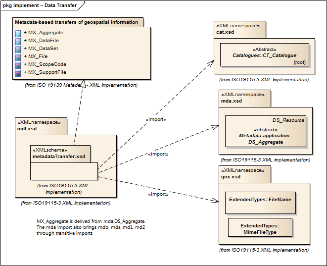
|
|
cat.1.0, gcx.1.0, mda.1.0, gco.1.0 |
||||
2019 |
Metadata for Data Transfer |
2.0 |
This namespace contains all classes needed for a complete metadata record for any resource and enables the description of data transfer (MX_*) elements. This is the most inclusive of the ISO 19115-3 namespaces so it should be used in situations where all 19115-3 capabilities are required. |
ISO 19115-1, Geographic Information - Metadata - Part 1: Fundamentals, 7.4.2, 7.4.3 |
data-transfer |

|
|
cat.1.0, gcx.1.0, mda.2.0, gco.1.0 |
||||
2019 |
Metadata with Schema Extensions |
1.0 |
Elements describing extensions to metadata standards. |
ISO 19115-1, Geographic Information - Metadata - Part 1: Fundamentals, 6.5.12 |
metadata-extension |
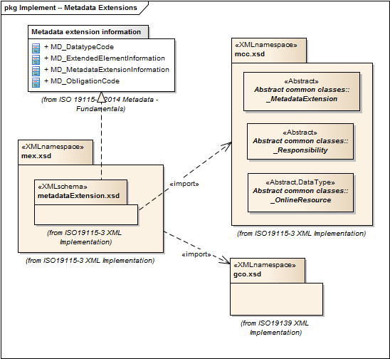
|
|
mcc.1.0, gco.1.0 |
||||
2019 |
Metadata for Maintenance Information |
1.0 |
Elements describing resource and metadata maintenance. |
ISO 19115-1, Geographic Information - Metadata - Part 1: Fundamentals, 6.5.6 |
maintenance-information |
|
|
mcc.1.0, gco.1.0 |
||||
2019 |
Metadata for Portrayal Catalog |
1.0 |
Elements for referencing portrayal catalogs. |
ISO 19115-1, Geographic Information - Metadata - Part 1: Fundamentals, 6.5.10 |
portrayal-catalog |
|
|
gco.1.0, mcc.1.0 |
||||
2019 |
Metadata for Resource Content |
1.0 |
Elements for describing resource structure and content. |
ISO 19115-1, Geographic Information - Metadata - Part 1: Fundamentals, 6.5.9 |
resource-content |
|
|
gco.1.0, fcc.1.0, lan.1.0, mcc.1.0, gmw.1.0 |
||||
2019 |
Metadata for Resource Content |
2.0 |
Elements for describing resource structure and content. |
ISO 19115-1, Geographic Information - Metadata - Part 1: Fundamentals AMENDMENT 1, 6.5.9 |
resource-content |

|
|
gco.1.0, mac.2.0, fcc.1.0, lan.1.0, mcc.1.0, gmw.1.0 |
||||
2019 |
Metadata for Resource Distribution |
1.0 |
Elements specifying how a resource is accessed. |
ISO 19115-1, Geographic Information - Metadata - Part 1: Fundamentals, 6.5.11 |
resource-distribution |
|
|
gco.1.0, mcc.1.0 |
||||
2019 |
Metadata for Resource Identification |
1.0 |
Elements for identifying resources. |
ISO 19115-1, Geographic Information - Metadata - Part 1: Fundamentals, 6.5.3 |
resource-identification |
|
|
lan.1.0, mcc.1.0, gco.1.0, gmw.1.0 |
||||
2019 |
Metadata for Resource Lineage |
1.0 |
Elements for describing resource lineage. |
ISO 19115-1, Geographic Information - Metadata - Part 1: Fundamentals, 6.5.5 |
lineage |

|
gco.1.0, mcc.1.0, gmw.1.0 |
|||||
2019 |
Metadata for Resource Lineage |
2.0 |
Elements for describing resource lineage. |
ISO 19115-1, Geographic Information - Metadata - Part 2: Extensions for acquisition and processing, 6.3.3 |
lineage |
|
gco.1.0, mcc.1.0, srv.2.0, gmw.1.0 |
|||||
2019 |
Metadata for Reference System |
1.0 |
Elements for describing Reference Systems. |
ISO 19115-1, Geographic Information - Metadata - Part 1: Fundamentals, 6.5.8 |
reference-system |
|
|
gco.1.0, mcc.1.0 |
||||
2019 |
Metadata for Spatial Representation |
1.0 |
Elements for describing spatial representations of resources. |
ISO 19115-1, Geographic Information - Metadata - Part 1: Fundamentals, 6.5.7 |
spatial-representation |

|
|
gco.1.0, gmw.1.0, mcc.1.0, dqc.1.0 |
||||
2019 |
Metadata for Spatial Representation |
2.0 |
Elements for describing spatial representations of resources. |
ISO 19115-1, Geographic Information - Metadata - Part 1: Fundamentals AMENDMENT 1, 6.5.7 |
spatial-representation |
|
|
gco.1.0, gmw.1.0, mcc.1.0, dqc.1.0 |
||||
2019 |
Referencing By Coordinates |
1.0 |
ISO 19111:2007 defines the conceptual schema for the description of spatial referencing by coordinates, optionally extended to spatio-temporal referencing. It describes the minimum data required to define one-, two- and three-dimensional spatial coordinate reference systems with an extension to merged spatial-temporal reference systems. It allows additional descriptive information to be provided. It also describes the information required to change coordinates from one coordinate reference system to another. |
ISO 19111, Geographic information — Spatial referencing by coordinates |
reference-coordinate |
No image available |
||||||
2019 |
Referencing By Coordinates Common |
1.0 |
abstract classes shared by multiple namespaces and is required in order to enable modularization of the XML implementation. |
ISO 19111, Geographic information — Spatial referencing by coordinates |
coordinate-system-common |
No image available |
||||||
2019 |
Metadata for Services |
2.0 |
Elements for describing services. |
ISO 19115-1, Geographic Information - Metadata - Part 1: Fundamentals, 6.5.14 |
services |
|
|
gco.1.0, mcc.1.0, mri.1.0 |