Metadata for Spatial Representation (MSR)
Metadata for Spatial Representation (MSR) Version: 1.3
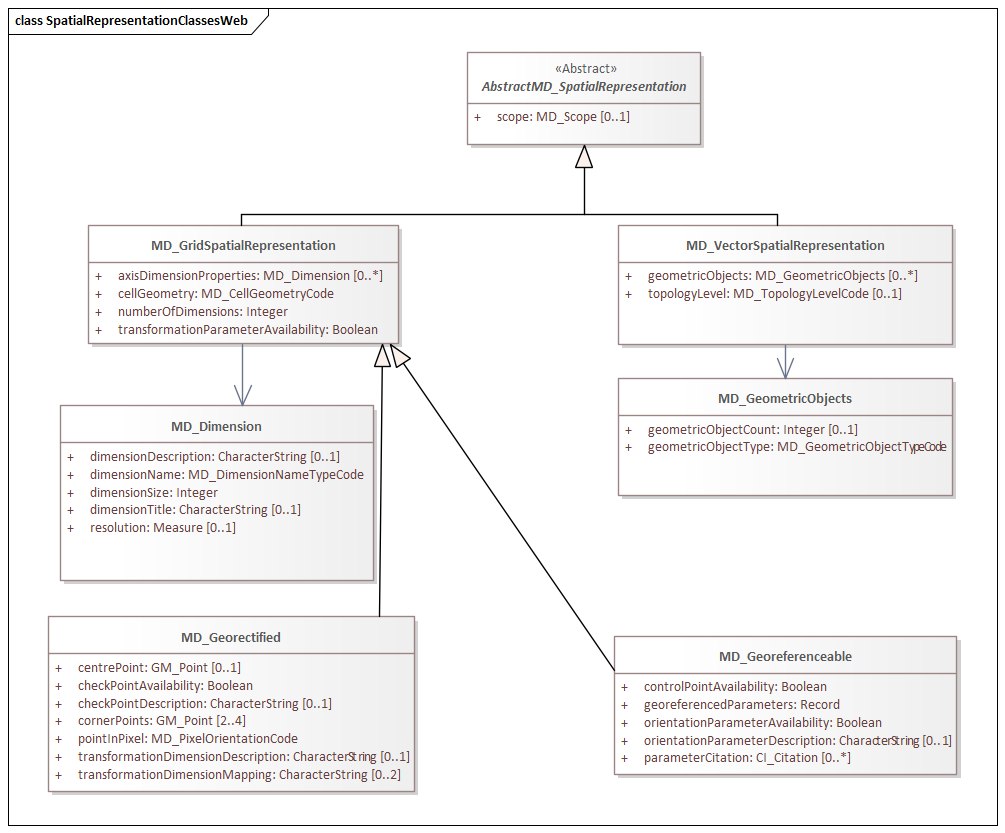
Figure 1. Classes in the msr namespace
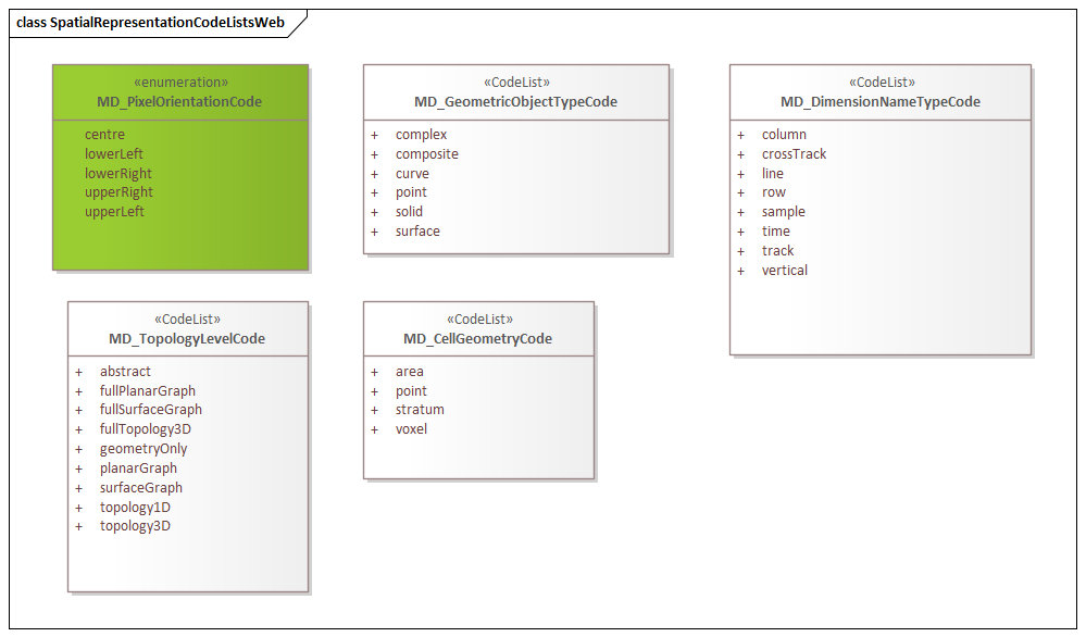
Figure 2. Code list(s) in the msr namespace
Description
MSR 1.3 is an XML Schema implementation derived from ISO 19115-1, Geographic Information - Metadata - Part 1: Fundamentals AMENDMENT 1, Clause 6.5.7. It includes elements for describing spatial representations of resources. The XML schema was encoded using the rules described in ISO/TS 19139:2007.
XML Namespace for msr 1.3
The namespace URI for msr 1.3 is https://schemas.isotc211.org/19115/-1/msr/1.3.
XML Schema for msr 1.3
msr.xsd is the XML Schema document to be referenced by XML documents containing XML elements in the msr 1.3 namespace or by XML Schema documents importing the msr 1.3 namespace. This XML schema includes (indirectly) all the implemented concepts of the msr namespace, but it does not contain the declaration of any types.
Related XML Schema for msr 1.3
spatialRepresentation.xsd implements the UML conceptual schema defined in ISO 19115-1, Geographic Information - Metadata - Part 1: Fundamentals AMENDMENT 1, Clause 6.5.7. It was created using the encoding rules defined in ISO 19118, ISO 19139.
https://schemas.isotc211.org/19115/-1/msr/1.3.0/spatialRepresentation.xsd contains the following classes:
-
AbstractMD_SpatialRepresentation
-
MD_GridSpatialRepresentation
-
MD_Georectified
-
MD_Georeferenceable
-
MD_VectorSpatialRepresentation
-
MD_Dimension
-
MD_GeometricObjects
https://schemas.isotc211.org/19115/-1/msr/1.3.0/spatialRepresentation.xsd contains references to the following codelists:
-
MD_DimensionNameTypeCode
-
MD_CellGeometryCode
-
MD_GeometricObjectTypeCode
-
MD_PixelOrientationCode
-
MD_TopologyLevelCode
spatialRepresentationImagery.xsd implements the UML conceptual schema defined in ISO 19115-2, Geographic Information - Metadata - Part 2: Extensions for acquisition and processing, Clause 6.5.7. It was created using the encoding rules defined in ISO 19118, ISO 19139.
https://schemas.isotc211.org/19115/-2/msr/2.2.0/spatialRepresentationImagery.xsd contains the following classes:
-
MI_Georectified
-
MI_Georeferenceable
-
AbstractMI_GeolocationInformation
-
MI_GCPCollection
-
MI_GCP
Related XML Namespaces for msr 1.3
The msr 1.3 namespace imports these other namespaces:
| Name | Standard Prefix | Namespace Location | Schema Location |
|---|---|---|---|
Data Quality Common Classes |
dqc |
||
Geographic Common Objects |
gco |
||
Geographic Markup Wrappers |
gmw |
||
Metadata Common Classes |
mcc |
||
CITation and Responsibility |
cit |
||
Metadata for Reference Systems |
mrs |
||
Geospatial MetaLanguage |
gml |
Schematron Validation Rules for mrs 1.3
Schematron rules for validating instance documents of the mrs 1.3 namespace are in mrs.sch.
Working Versions
When revisions to these schema become necessary, they will be managed in the ISO TC211 Git Repository.